


Title Page
-
Fuel Hazard Assessment Form
-
Sampling Location
-
Location
-
Date Assessed
-
Assessors
-
Vegetation Type
Plot Information
-
Plot Number
-
Zone
-
Easting (GDA94 MGA UTM)
-
Northing (GDA94 MGA UTM)
-
Location
Canopy Height (Assess over 20m radius)
-
Average Height to Top of Canopy (measured in meters)
-
Average Height to Base of Canopy (measured in meters)
-
Photos (if applicable)
Bark Fuel (Assess over 20m radius)
-
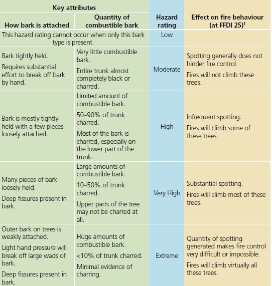
TABLE 1: Fine fibrous bark types including String Bark
-
Stringy Bark Fuel Hazard
-
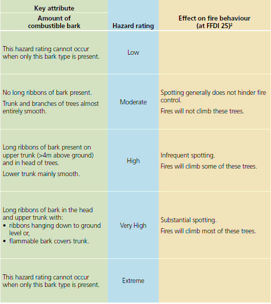
TABLE 2: Ribbon or candle bark types
-
Ribbon Bark Fuel Hazard
-
TABLE 3: Other bark types
-
Other Bark Fuel Hazard
-
Photos (if applicable)
Bark Fuel Hazard
-
Bark Fuel Hazard<br>(Select if Bark Hazard rating from above that will be used to determine Overall Fuel Hazard. Only use the Stringy Bark hazard rating if more than 10% of the trees are Stringy Bark AND it has the highest rating. Otherwise use the bark with the next highest rating.)
Elevated Fuel Later (Assess over a 10m radius)
-
Elevated % Cover
-
Elevated % Dead
-
Elevated Fuel Average Height (in meters)
-
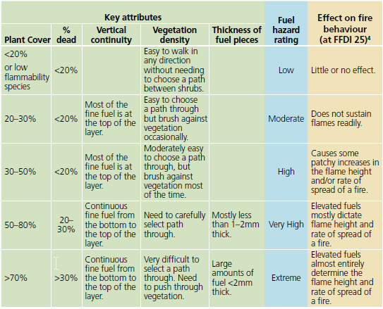
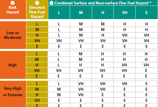
TABLE 4: Elevated find fuel hazard
-
Elevated Fuel Hazard
-
Photos (if applicable)
Near-surface Fuel Layer (Assess over 10m radius)
-
Near-surface % Cover
-
Elevated % Dead
-
Near-surface Average Height (in centimeters)
-
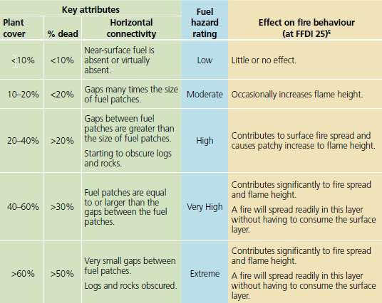
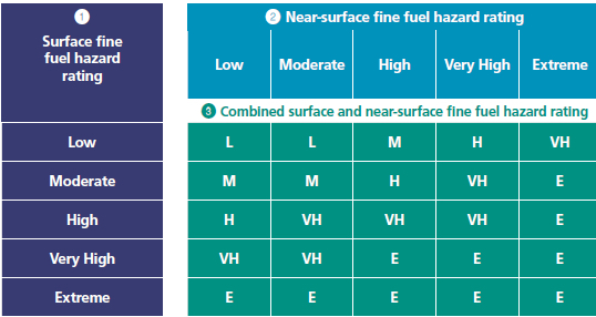
TABLE 5: Near-surface fine fuel hazard
-
Average Litter Depth (in millimetres)
-
Near-surface Fuel Hazard
-
Photos (if applicable)
Surface Fuel Layer (Assess over 10m radius)
-
Surface Litter % Cover
-
TABLE 6: Surface fine fuel hazard
-
Surface Fuel Hazard

Combined Surface and Near-surface Fine Fuel Hazard Calculation (Refer section 7)
-
TABLE 7: Combined Surface and Near-surface fine fuel hazard
-
Combined Hazard
Combined Fuel Hazard Calculation (Refer section 8)
-
TABLE 8: Overall Fuel Hazard Rating
-
Overall Fuel Hazard
-
Are the plots representative of the average fuel across the sampling location? If no, explain any significant difference between plots. For example, wet gully runs through the sampling area, no plots were located in this gully
Chances of Extended Attack Success
-
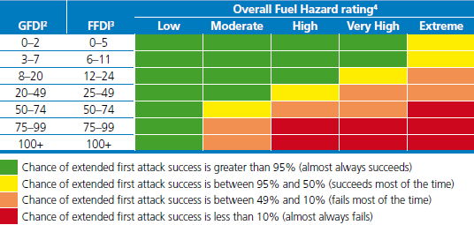
TABLE 9: Chances of Extended First Attack Success
-
Grass Fire Danger Index (GFDI)
- 0-2
- 3-7
- 8-20
- 20-49
- 50-74
- 75-99
- 100+
-
Forest Fire Danger Index (FFDI)
- 0-5
- 6-11
- 12-24
- 25-49
- 50-74
- 75-99
- 100+
-
Chance of extended first attack success rates
Indicative Fuel Loads
-
TABLE 10: Indicative Fuel Loads (tonnes)
-
Fuel Type
-
Fuel Hazard Level
-
Fuel Hazard Rating


