


Title Page
-
Site conducted
-
Location
-
Conducted on
-
Client
-
Client site contact
-
Client contact no.:
-
Purchase Order
DBYD plans
-
DBYD plans available on site
- Yes
- No
- N/A
Supplied by?
-
-
DBYD job no.
-
Date requested
-
DBYD Current
-
Services identified on site from DBYD
- Telstra
- Optus
- NBN
- Water
- Fire service
- Sewer
- Power
- Gas
- Municipal Authority- Stormwater
- Municipal Authority- other
- Stormwater- private
- Other
-
Nominate other utility owner/s
-
Other authorities contacted for plans
-
Nominate authority
The 5 P's of safe excavation
-
PLAN - Plan ahead by lodging your BYDA request at least 2 days prior to starting works on site
-
PREPARE- Prepare by reviewing the utility plans and contacting the asset owners if you need assistance. Look for onsite asset clues such as pit lids, meters, marker posts etc. Engage a DBYD certified Locator to assist in locating assets electronically before potholling.
-
POTHOLE- Pothole, if permitted, using the asset owners stated method as stated on the plans or information pack.
-
PROTECT- If potholing has occurred, protect the infrastructure by various means: such as communicating to all relevant parties on site, erecting barriers and or marking the location of the exposed infrastructure.
-
PROCEED- Only proceed after you have planned, prepared, potholed (unless prohibited) and have protective measures in place
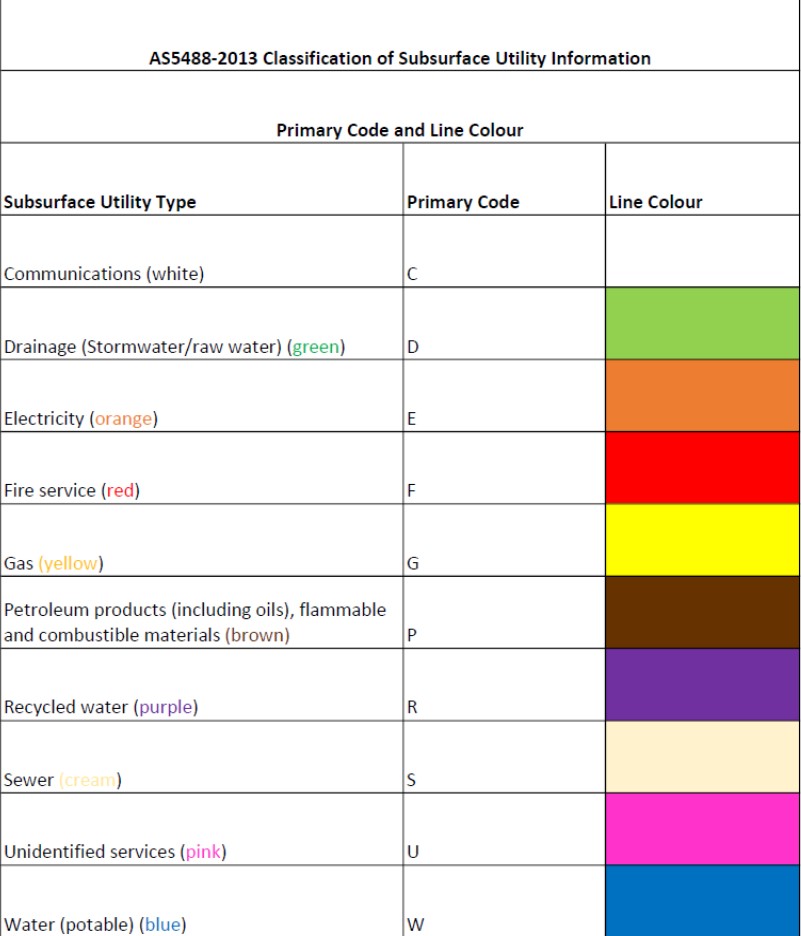
AS 5488 Classification of Subsurface Utility Information
Services found on site
-
Telstra located, marked, depths marked, photos taken?
- Yes
- No
- N/A
-
Quality Level as per AS 5488:2019
-
Notes
-
NBN located, marked, depths marked, photos taken?
- Yes
- No
- N/A
-
Quality Level as per AS 5488:2019
-
Notes
-
Optus located, marked, depths marked, photos taked?
- Yes
- No
- N/A
-
Quality Level as per AS 5488:2019
-
Notes
-
Water located
- Yes
- No
- N/A
-
Quality Level as per AS 5488:2019
-
Notes
-
Fire Service
- Yes
- No
- N/A
-
Quality level as per AS 5488:2019
-
Notes
-
Sewer located
- Yes
- No
- N/A
-
Quality Level as per AS 5488:2019
-
Notes
-
Power located
- Yes
- No
- N/A
-
Quality Level as per AS 5488:2019
-
Notes.
-
Earthing Located
- Yes
- No
- N/A
-
Quality Level as per As 5488:2019
-
Pole Numbers or reference equipment
-
Notes
-
Municipal Authority- Stormwater
- Yes
- No
- N/A
-
Quality level as per AS 5488:2019
-
Notes
-
Municipal Authority- other
- Yes
- No
- N/A
-
Quality level as per AS 5488:2019
-
Notes
-
Gas located
- Yes
- No
- N/A
-
Quality Level as per AS 5488:2019
-
Notes
-
Private stormwater
- Yes
- No
- N/A
-
Quality level as per AS 5488:2019
-
Notes
-
Vic Roads
- Yes
- No
- N/A
-
Quality level as per AS 5488:2019
-
Notes
-
Other services identified
- Yes
- No
- N/A
-
Known service
-
Quality Level as per AS 5488:2019
-
Quality Level as per AS 5488:2019
-
Notes
-
Services not found that are listed on DBYD
Photos
-
Photos
Add drawing
-
Scan Drawing
Disclaimer
-
Locate Cables will not be held responsible for any assets that are not identified through the Dial Before You Dig Process, or by clients own plans. Although Locate Cables accredited locator takes
every possible precaution to ensure that locations provided are accurate (within the tolerances of AS:5488 2019), all asset locations are to be treated as indicative only. It is the responsibility of the client to visually locate all located assets. -
AS 5488-2019 CLASSIFICATION OF SUBSURFACE UTILITY INFORMATION (SUI)
This Standard provides a framework for the classification of subsurface utility location and attributes information in terms of specified quality levels. The objective of this Standard is to provide utility owners, operators and locators with a framework for the consistent classification of information concerning subsurface utilities. Project risks related to underground utilities can then be properly managed.
A quality level describes the amount and accuracy of information that is collected or held on a subsurface utility. There are four quality levels—D, C, B and A.
Quality Level A (QLA): Information is the highest possible level of accuracy and is obtained by exposing the underground utility using a non-destructive excavation (potholing) technique. The vertical information for this locating method is to the top or shallowest part of the located service. The 3D location is recorded by survey as an X, Y, Z coordinate. Tolerance +/- 50mm horizontal and vertical.
Quality Level B (QLB): Information is collected by designating the horizontal and vertical location of underground utilities by using electromagnetic pipe and cable locators, sondes or flexi-trace. This is the most common form of utility locating and although an X, Y and Z axis can be established it is not always entirely accurate due to differing electromagnetic fields, soil conditions and multiple banks of cables affecting the locating signal. Tolerance +/- 300mm horizontally and vertically
Quality Level C (QLC): Information is collected by correlating the survey of visible utility surface features such as marker plates or water hydrants and acquired dial-before-you-dig plans to “draw” a string which shows the approximate position of services. This method does not usually show multiple banks of cables and does not always show three-dimensional information. Tolerance +/- 300mm horizontally and vertically.
Quality Level D (QLD): Information is the most basic level of utility locations using only information based on existing Dial-Before-You-Dig plans and by measuring boundary offsets etc. This method of utility locations should always be treated as an indication of the presence of a service only and should not be used for design. GPR scans are included in this level.
Sign off
-
M McGoldrick
-
Certified Locator Organisation proof


